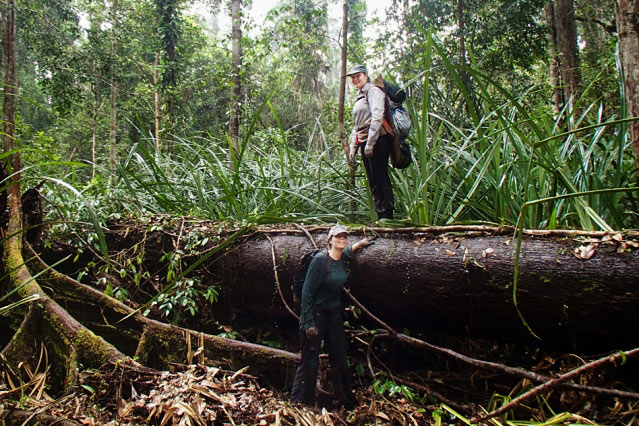
A team led by Charles Harvey, an MIT professor of civil and environmental engineering, and Alison Hoyt, PhD ’17, a postdoc at the Max Planck Institute for Biogeochemistry, has used precise satellite elevation data gathered from 2007 to 2011 to document the environmentally dangerous effects of peatland drainage in Southeast Asia.
Tropical peatlands are permanently flooded forests where fallen leaves and branches accumulate for centuries rather than decomposing. In less than three decades, most of Southeast Asia’s peatlands have been deforested, drained, and dried for agriculture or other purposes, leaving them vulnerable to wildfires that spew pollution and greenhouse gases. Even when unburned, dried peat rapidly decomposes, releasing carbon and causing the ground surface to subside, or sink, toward sea level faster than sea level is rising.

ALISON HOYT
Until now, measuring these effects has required arduous treks through trackless swamps. But thanks to interferometric synthetic aperture radar (InSAR), which can detect changes in surface elevation with an accuracy of millimeters, the team determined that over 90% of the peatland studied was subsiding at an average of almost an inch a year.
“This is definitely a proof of concept on how satellite data can help us understand environmental changes,” Hoyt says. “This has really exciting management implications.”
Roofing is a crucial aspect of a building's structure as it protects the interior from…
When it comes to maintaining a home, one of the most important aspects to consider…
Galveston, Texas, is quickly emerging as a premier destination for deep-sea fishing enthusiasts in search…
In the ever-evolving landscape of construction and building maintenance, sustainability has emerged as a crucial…
Minnesota, celebrated for its picturesque rural landscapes and vibrant urban centers such as St. Paul…
In the realm of kitchen renovations, cabinetry plays a pivotal role in shaping both the…